What is the Madden–Julian Oscillation?
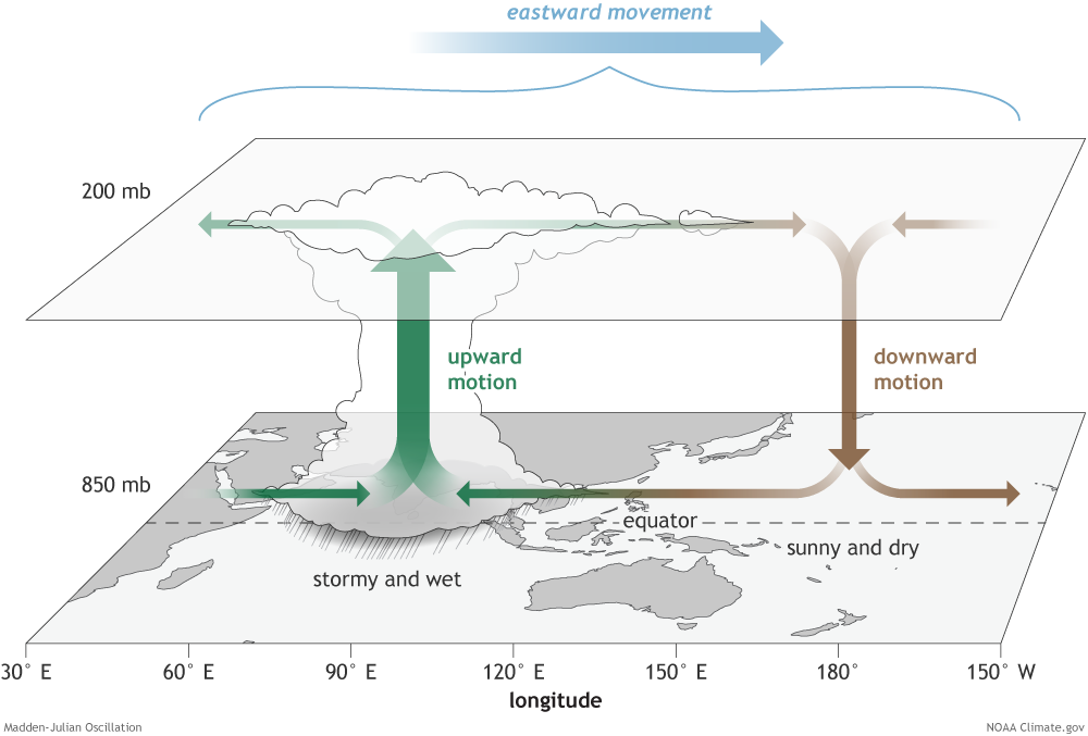
The Madden–Julian Oscillation (MJO) is the dominant form of intra-seasonal variability in the tropical atmosphere. It is essentially a large-scale disturbance of clouds, rainfall, winds and pressure that moves eastward along the equator.
Unlike climate phenomena such as El Niño–Southern Oscillation (ENSO) that influence weather on yearly timescales, the MJO operates within a 30–60 day cycle, causing alternating periods of enhanced and suppressed rainfall across the tropics.
First identified in 1971 by Roland Madden and Paul Julian, the phenomenon primarily develops over the Indian Ocean and western Pacific warm pool.
In simple terms, the MJO acts like a moving pulse of tropical rainfall, periodically strengthening or weakening weather systems across the globe.
How the MJO Works
The Madden–Julian Oscillation consists of two alternating phases:
Enhanced Convective Phase (Active Phase)
- Strong upward movement of warm, moist air
- Formation of deep convective clouds
- Heavy rainfall and thunderstorms
- Lower outgoing longwave radiation (OLR) due to thick cloud cover
Suppressed Convective Phase
- Descending dry air
- Reduced cloud formation
- Dry and stable atmospheric conditions
- Higher OLR values
These phases travel eastward along the equatorial belt, forming a large atmospheric circulation pattern that moves around the globe roughly every 30–60 days.
Key Characteristics of the MJO
- Time Scale: 30–60 days (sometimes up to 90 days)
- Speed: About 5 m/s eastward propagation
- Latitude Range: Mostly between 30°N and 30°S
- Primary Region: Indian Ocean → Maritime Continent → Pacific Ocean
Scientists monitor the MJO using:
- Outgoing Longwave Radiation (OLR) – indicates strength of convection
- RMM Index (Real-time Multivariate MJO Index) – tracks its strength and location across 8 phases

The Monsoon Connection: Why MJO Matters for India
The MJO strongly influences the Indian Summer Monsoon.
Active Phase over the Indian Ocean
When the enhanced convective phase moves over the Indian Ocean, it leads to:
- Increased moisture transport
- Strong convection
- Heavy rainfall over India
This phase often supports monsoon onset and active rainfall spells.
Suppressed Phase
When the MJO moves eastward toward the Pacific Ocean, the suppressed phase develops over India.
This leads to:
- Reduced rainfall
- Break periods in the monsoon
These “monsoon breaks”, particularly during July–August, are closely linked with the eastward movement of the MJO.
Role in Cyclone Formation
The MJO also affects tropical cyclone activity.
The enhanced convective phase creates conditions favorable for cyclone development by:
- Increasing low-level moisture
- Strengthening westerly winds
- Enhancing atmospheric instability
As a result, periods of strong MJO activity often coincide with increased cyclone formation in tropical ocean basins.
MJO vs ENSO
| Feature | MJO | ENSO |
| Time scale | 30–60 days | 2–7 years |
| Nature | Moving tropical disturbance | Ocean–atmosphere anomaly in Pacific |
| Spatial behaviour | Eastward propagating | Mostly stationary |
| Impact on monsoon | Controls active & break phases | Influences overall strength |
Thus, ENSO determines whether a monsoon season may be weak or strong, while the MJO determines how rainfall is distributed within that season.
Why the MJO is Important
Understanding the MJO helps meteorologists improve sub-seasonal weather forecasting.
It plays a role in:
- Monsoon prediction
- Cyclone forecasting
- Flood and extreme rainfall warnings
- Agricultural planning
Because the MJO can be tracked 2–3 weeks in advance, it provides valuable guidance for weather forecasting and disaster preparedness.
Key Takeaways
- MJO is the dominant intra-seasonal oscillation in the tropics.
- It moves eastward across the equatorial oceans every 30–60 days.
- Consists of enhanced and suppressed rainfall phases.
- Plays a major role in monsoon variability and cyclone formation.
- Tracked using OLR observations and the RMM index.